Tag Archive for Surface

Autodesk labs | Interactive Terrain Shaping for Civil 3D

imageThe toolset that many have been waiting for was just released on Autodesk labs. The Interactive Terrain Shaping for AutoCAD Civil 3D. These tools give Civil 3D users the capability to shape and mold various features related to grading, with direct pick, apply, and drag functionality. The Labs site stated that the intent was to "facilitate the development of comprehensive grading plans that can be easily tuned through the development cycle".

image

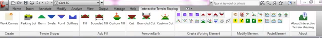
A new Ribbon tab is installed in Civil 3D, and contains numerous tools including terrain feature shapes, including:

Read more

How to do business development with SITEOPS!

WMWebinar_Header

We invite you to a special webinar session in which A.J. Whitaker, PE, PLS and Director of Site Development for Ware Malcomb, shares business development tactics and best practices for getting the most out of SITEOPS, patented online collaborative CAD software.

A.J. will share real-world examples of how SITEOPS has helped him win projects, find new solutions for sites, and “wow” clients through the power of online optimization and collaboration. “The clients love it and we’re winning new business as a result.”


When: Wednesday, June 23 – 2PM-3PM EST
Guest Speaker: A.J. Whitaker, PE and PLS, Director of Site Development
Who should attend: Engineers, Architects, CEO/VPs of AEC firms

Register today to reserve your seat:  http://www.siteops.com/news/civil.shtml

3D DEM rendering with Map and C3D

If you have never used a DEM (Digital Elevation Model) file I encourage you to search one out and put it to work for you. They are great for those preliminary designs or doing hydrology basins. DEM models can be downloaded for free from most Geospatial websites. They are excellent for generating relief maps so you can get a better perspective of the land or to impress your clients with 3D views of their property.  What I want to do with them is show you how to create 3d rendered DEM. Most of you know that you can do it in Civil3D but did you know you can do it quicker and easier with the Map tools.

Lets jump in………..

Read more

Catchment Area

One of the nifty tools in 2009 is the catchment area. It is the opposite of the rain drop feature. It saves time especially when trying to figure drainage areas. I use the 2D option, so I can get an area. I haven’t played with the 3D option, as I think it would give erroneous areas since it basically drapes itself over the surface and follows every hill and valley.

THEN – I can convert this into a parcel and get a nice area label for my Drainage Area mapping.

Nifty, eh?