
If you’ve messed around with the Surface Analysis styles at all, you might have noticed that you cannot make the hatch anything besides solid colors.
Did you know that you can have your .ctb help out?
Assign colors to your analysis that you can make “special” in your ctb. (I am using 1,2,3,4,etc. just to make it easy for this example)

Edit the “Fill Style” portion of your ctb (or you can make a special ctb just for surface analysis)
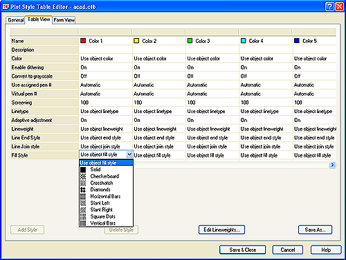
Plot using that .ctb and check out the magic.

Special thanks to the puppetmaster. You know who you are.


This does not apply to the article directly, but is the 2009 version of “Mastering Civil 3D” going to press anytime near the release of Civil 3D 2009 and are you going to add a section of this type of blogger hint?
Dana and I are working diligently on updates and changes now. We do have to wait for essentially complete software to update and make changes.
We might include some of these tips in sidebars, etc, but they’re generally not included in the main lessons. I think I have one in Profiles about using cut and paste to make some labels do things that aren’t intended. In general, we avoid these type of items as they’re very use case specific. I’m thinking (hoping,) you’ll see a Best of the Blogs class at AU where I’ll be running through a number of these type tips and hacks. That document would then be available to all afterwards.
I recently submitted a wish list to AUGI for this very thing:
Description: Show and Print transparent colors as transparent
How Used: Create surfaces and show them in elevation color banding style. To be able to make the solid colors 50% transparent as to see the raster image below the surface, then plot as such (and not simply as a solid color). The colors should also not be limited to 2 colors between elevation bands (ie, 0-2′ green, 2-4′ blue). There should be a gradient interpolation from green to blue.
THIS SHOULD BE A STANDARD FOR CIVIL much like GIS. I LOVE the MAPWSPACE command to view tranparent color maps etc, PROBLEM is you cannot print to transparency! Very frustrating. I learned the hard way by developing this beautiful map just in time for a big presentation to a very important client, only to be embarrassed by the fact that I could only plot solid colors over my raster image. I hope this gets fixed soon.
Any idea how to control the scaling of the fill?
This type also works for STB’s too…Named Plot Styles.
To Trey,
I have been sucessful using a very fine version of the DOTS hatch pattern to overlay a hatch color onto an image. If you want to use the surface analysis, Dana’s method should allow you to do that. Just remeber that if you really want the hatch to appear transparent, you will have to make the patten scale rather small AND set the linewieght for that object/layer/ctb to a very small size. It’s a balance you will have to play with, and unfortunately dots don’t print preview at the set lineweight they plot with, so you will have to actually send it to a printer. When you get it right, however, you really can’t tell that it’s not a trasparent color overlay.
DWFit!
Thanks for this tip. This will save quite a bit of time!!! Now to play around with it and see if we can get it to work 🙂